(Department of Interior Photo)
Tweet by @SecBernhardt. (2020, October 4). Great partnership at the local level has led to @BLMNational providing an incredible opportunity for socially distanced recreation at Glade Run Recreational Area. Get out and enjoy our great public lands.
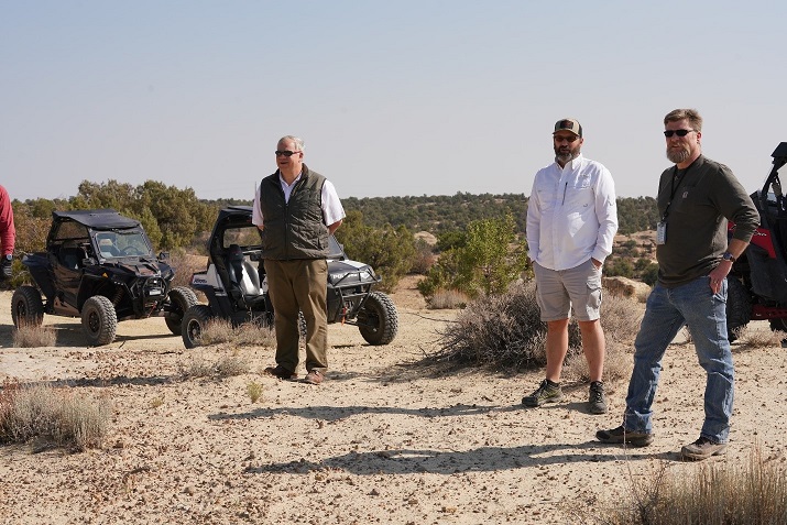
Sec. Bernhardt Discusses BLM Partnership Benefitting OHVs
On Oct. 4, U.S. Secretary of the Interior David Bernhardt was in Farmington, NM and visited the Glade Run Recreation Area. During his visit, Sec. Bernhardt discussed the recently developed partnership between the Bureau of Land Management and Glade Run to improve options for off-highway vehicles and plans to develop a campground. Sec. Bernhardt described the partnership as a model of various entities coming together to improve an outdoor recreation amenity. “It really is an example of what I hope we can do in partnering with communities to expand recreational opportunities,” said Sec. Bernhardt.
The recently passed Great American Outdoors Act provides the necessary funding to address deferred maintenance at facilities across the country. Sec. Bernhardt said locations across the United States have lists of deferred maintenance that needs to be completed because “really for 40 years, it’s not been our focus.”
The Glade Run Recreation Area is comprised of 19,000 acres and is split into two off-highway vehicle use zones. The northern three-quarters of the Glade are managed for limited trail use and 3,800 acres on the south end are managed as an open OHV area. Approximately 42 miles of marked trails for motorized trail bike and mountain bike riders are located in the limited OHV portion of the Glade Run Recreation Area.
(U.S. Forest Service Photo)
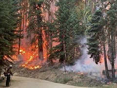
Unprecedented Fires Close California’s National Forests and State Parks
The unprecedented fires on public lands throughout California prompted state and federal officials to temporarily close 22 state parks and all 18 national forests that encompass more than 20 million acres across California. “The number of large fires and extreme fire behavior we are seeing across the State is historic,” said Randy Moore, Regional Forester for the USDA Forest Service Pacific Southwest Region. “These temporary closures are necessary to protect the public and our firefighters, and we will keep them in place until conditions improve and we are confident that National Forest visitors can recreate safely. I ask all Californians and visitors to take these closures and evacuations seriously for their own safety and to allow our firefighters to focus on the mission of safely suppressing these fires.” The closures took place effectively on Sept. 9.
“We understand how important access to national forests is to our visitors,” said Moore. “As we evaluate fire and weather conditions on a daily basis, we will continue to make adjustments to ensure safe visitation. Our aim continues [to be] to prevent any new fires on the landscape.”
Although the U.S. is only halfway through wildfire season, this year is one of the worst in history. According to recent figures from the California Department of Forestry and Fire Protection, there have been nearly 8,000 wildfires that have burned more than 3.4 million acres in California. Since August 15, when the state’s fire activity elevated sharply, there have been 25 fatalities and some 5,400 structures destroyed. Click here to access the California daily wildfire updates and here to access the list of closed state parks.
One-Year Extension for the RTP Included in Stopgap Spending Measure
Just a few hours before the Sept. 30 midnight deadline that could have caused a government shutdown, the Senate passed the Continuing Appropriations Act, 2021 and Other Extensions Act on an 84-10 vote. This short-term funding bill will keep the government funded at current levels through Dec. 11. The House had previously passed the measure on a 359-57 vote. The President signed the stopgap spending measure within an hour after the midnight deadline, ensuring that the government would remain open.
Of interest to ARRA members, the stopgap measure also extends the highway bill through September 30, 2021. The highway bill includes the Recreational Trails Program (RTP) which is a critical tool for developing and maintaining recreational trails across the country.
The stopgap spending measure ensures another government funding debate after the November elections. In order for Congress to avoid a shutdown on Dec. 12, they will need to pass either another CR or the remaining 12 FY 2021 funding bills.
States Continue to Increase Recreational Access
As states continue to reopen from COVID-19 restrictions, they are increasing recreational access to roads, trails, picnic areas, restrooms, and wilderness. The Bureau of Land Management (BLM) continues to work with federal, state, and local authorities to closely monitor the COVID-19 pandemic and use a phased approach to increase access on a case-by-case basis. The following recreational area reopened in September:
- Taos, NM – With the easing of public health and safety restrictions enacted by the State of New Mexico health officials, the Bureau of Land Management (BLM) announced that the Taos Field Office increased access to the Orilla Verde Recreation Area and some areas of the Wild Rivers Campgrounds. On Sept. 3, the Recreation Area opened the following campgrounds: Arroyo Hondo, Lone Juniper, Pilar, Rio Bravo, Rio Pueblo, and Taos Junction. The following campgrounds were opened at 50% capacity: Big Arsenic, El Aguaje, Little Arsenic, and Montoso.
- Moreno Valley, CA – The Bureau of Land Management (BLM) Palm Springs-South Coast Field Office rescinded a closure order restricting access to a portion of the Pacific Crest Trail managed by the BLM in the vicinity of the Valley Fire in the Lawson Valley and Japatul areas in San Diego County. The Valley Fire burned approximately 17,100 acres and is 95 percent contained.
- Butte, MT – The Bureau of Land Management’s Butte Field Office rescinded an Emergency Closure Order issued earlier this month temporarily restricting camping, day use, road access, and hunting in the Little Whitetail and Hay Canyon areas in Jefferson County due to the State Creek Fire.
- Spokane, WA – The Bureau of Land Management (BLM) Spokane District lifted the regulated fire closure on public lands administered by the BLM and the Bureau of Reclamation (BOR) in eastern Washington. The termination of the regulated fire closure was effective Wednesday, Sept. 30, 2020 at 12:01 a.m. in the following counties: Adams, Asotin, Benton, Chelan, Columbia, Douglas, Ferry, Franklin, Garfield, Grant, Kittitas, Klickitat, Lincoln, Okanogan, Pend Oreille, Spokane, Stevens, Walla Walla, Whitman, and Yakima.
According to BLM, dry conditions due to a lack of precipitation this spring, above normal temperatures, and mats of unburnt fuel from last year are resulting in an above-normal fire potential. BLM issued fire restrictions to the following areas:
- Casper, WY – The Bureau of Land Management reminds the public to continue to be aware of and follow fire restrictions on public lands as temperatures begin to cool and local area hunters take to the outdoors as the fall season arrives.
- Cañon City, CO – In response to recent and forecasted precipitation across the region, the Bureau of Land Management’s Royal Gorge Field Office moved from Stage 2 to Stage 1 fire restrictions on BLM-managed lands in Park County. The change in restrictions was based on current conditions and is consistent with the US Forest Service-Pike and San Isabel National Forests’ current restrictions. The change in restrictions became effective on Sept. 18.
- Cedar City, UT – In order to protect public health from preventable human-caused fires, fire restrictions will continue for the foreseeable future on Bureau of Land Management public lands in Piute, Sanpete, Sevier, Wayne, Washington, Iron, Beaver, Garfield, and Kane counties due to a continued lack of adequate monsoonal moisture.
- Meeker, CO – The White River and Little Snake field offices, along with Moffat and Rio Blanco counties, reverted from Stage 2 to Stage 1 fire restrictions on September 30. The Colorado River Valley Field Office and Kremmling Field Office in Eagle County will remain in Stage 1 restrictions, while Kremmling Field Office in Grand, Jackson, Routt, and Summit counties remained in Stage 2 fire restrictions.
BLM has issued temporary closures for:
- Medford, OR– As a result of extreme fire activity, the Bureau of Land Management Medford District temporarily closed all BLM-administered public lands from Township 38S south to the California border and from Range 2E east to the Klamath County border.
- Roseburg, OR – The Bureau of Land Management (BLM), Roseburg District, closed public lands east of I-5, within the Swiftwater Field Office, until the Archie Creek fire is declared controlled. The lands are located in Douglas and Lane County, Oregon.
- Bakersfield, CA – The Bureau of Land Management Bakersfield Field Office issued a temporary emergency closure of the Case Mountain Extensive Recreation Management Area near the town of Three Rivers in Tulare County due to the proximity of the Sequoia Complex Fire (SQF Complex). The closure is effective immediately and remains in effect until further notice.
- Portland, OR – As a result of extreme fire activity, the Bureau of Land Management has temporarily closed all public lands managed by the Northwest Oregon District east of Interstate 5, effective immediately. This expands the previous closure of developed campgrounds in the area, to include all BLM-administered lands, roads, sites, and trails.
- Portland, OR – Extreme fire activity, fueled by a rare fire weather event with low humidity and strong east winds of 15 to 30 mph and gusts up to 50 mph, occurred on several fires located in western Oregon. To prevent human-caused fire and reduce wildfire potential, the Bureau of Land Management has instituted several closures and new fire-use restrictions.